Shrimp Season
Licensed fishermen may only harvest shrimp during open shrimp seasons (unless permitted to harvest live bait under a Special Bait Dealer's Permit).
The Louisiana Wildlife and Fisheries Commission sets shrimp seasons for Louisiana’s state waters by area according to LDWF’s recommendations based on environmental conditions and the growth rates, distribution, and abundance of shrimp. They also consider input from the Shrimp Task Force and other stakeholders.
In general, shrimp seasons by area are:
- Inside waters: open when enough market-sized shrimp are available in these waters for harvest. The spring/brown shrimp season generally runs May to July. The fall/white shrimp season is generally open mid-August to mid-December; some waters stay open into January.
- Outside waters: year-round, except from mid or late December to April or May in certain areas to protect small white shrimp and allow them to grow to market size. The Commission can close these waters at other times of the year if necessary.
- Federal waters off Louisiana: year-round (managed by the Gulf of Mexico Fishery Management Council and NOAA Fisheries).
Current Season
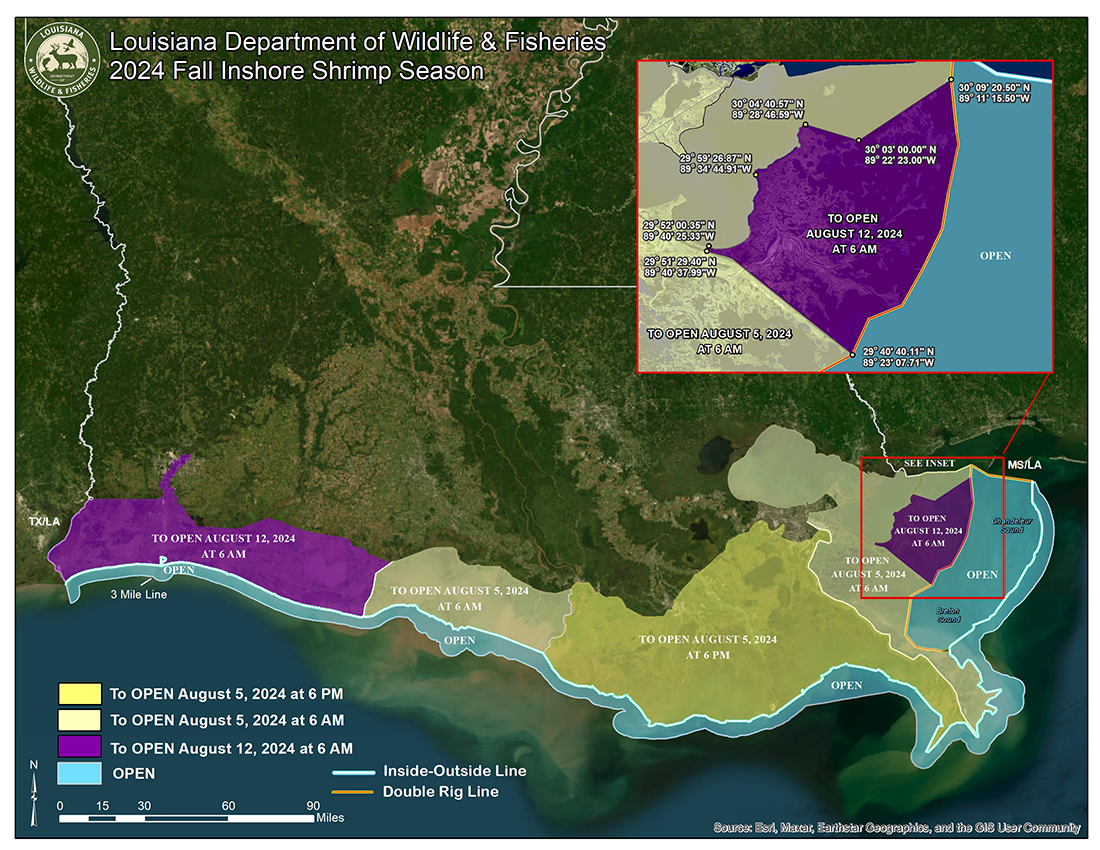
The Louisiana Wildlife and Fisheries Commission set the opening dates for the 2024 fall inshore shrimp season based on information provided by biologists from the Louisiana Department of Wildlife and Fisheries (LDWF), input from the Louisiana Shrimp Task Force, and public comments.
Season openings are as follows:
- From the Mississippi/Louisiana state line westward to the eastern shore of South Pass of the Mississippi River to open at 6:00 a.m. August 5, 2024, except for the area as described below, which will open at 6:00 a.m. August 12, 2024:
- From a point at the intersection of the eastern shore of the MRGO and the Shell Beach Cut at 29 degrees 51 minutes 29.40seconds north latitude, 89 degrees 40 minutes 37.99 seconds west longitude; thence northerly to a point where Shell Beach Cut and the south shore of Lake Borgne intersect (29 degrees 52 minutes 00.35 seconds north latitude, 89 degrees 40 minutes 25.33 seconds west longitude); thence easterly and northerly following the southern shore of Lake Borgne and the western shore of the Biloxi Marsh to Pointe Aux Marchettes (29 degrees 59 minutes 26.87 seconds north latitude, 89 degrees 34 minutes 44.91 seconds west longitude); thence northeasterly to Malheureax Point (30 degrees 04 minutes 40.57 seconds north latitude, 89 degrees 28 minutes 46.59 seconds west longitude); thence southeasterly to a point on the western shore of Three-Mile Pass (30 degrees 03 minutes 00.00 seconds north latitude, 89 degrees 22 minutes 23.00 seconds west longitude); thence northeasterly to a point on Isle Au Pitre (30 degrees 09 minutes 20.50 seconds north latitude, 89 degrees 11 minutes 15.50 seconds west longitude), which is a point on the double–rig line as described in R.S. 56:495.1(A)2; thence southerly following the double rig line to where it intersects with the MRGO (29 degrees 40 minutes 40.11 seconds north latitude, 89 degrees 23 minutes 07.71 seconds west longitude); thence northwesterly along the eastern shore of the MRGO to the point of origin.
- From the eastern shore of South Pass of the Mississippi River westward to the Atchafalaya River Ship Channel at Eugene Island, delineated by the red Channel Buoy Line to open at 6:00 p.m. August 5, 2024.
- From the Atchafalaya River Ship Channel at Eugene Island as delineated by the red Channel Buoy Line westward to the western shore of the Freshwater Bayou Canal to open at 6 a.m., August 5, 2024.
- From the western shore of the Freshwater Bayou Canal westward to the Louisiana/Texas state line to open at 6 a.m., August 12, 2024.
How do we determine shrimp seasons?
LDWF biologists and managers recommend shrimp seasons based on a shrimp species’ annual life cycles and growth rates, which are heavily influenced by environmental conditions. LDWF biologists continually monitor shrimp populations and environmental conditions in Louisiana’s marshes, coastal lakes, and bays. At hundreds of sample locations, they tow trawls through the water, count and identify the species they catch, measure a random selection of the shrimp catch, and record the data. They also record water conductivity, temperature, salinity, and dissolved oxygen levels. They then compile the data and plug it into mathematical models. These models help biologists project when the majority of the shrimp population within each the state’s major estuarine basins will reach market size. The Commission uses these projections to determine when and where to open and close the shrimp fishery. Adjusting seasons in response to the conditions that influence shrimp populations helps fishermen have more productive shrimping trips.